When I came aboard NCA in April 1959, much of the northern areas of the upper midwest were designated as “uncontrolled air space”. That area included the entire upper peninsula of Michigan which was commonly referred to as the “UP”. The towns that NCA served in that area at that time included, Ironwood, Houghton/Hancock, Marquette, Iron Mountain, Escanaba, Menominee/Marinette and Sault Ste Marie, all in the UP. And then there was Ashland, Rhinelander and on the summer schedule, we also served Land-O-Lakes in Northern Wisconsin. Looking across into Northern Minnesota, I am sure that the same can be said for Hibbing, International Falls and Thief River Falls as well as out in the Dakotas; those towns and cities that were in the northern tier. This vast area was, in early 1959 and into the early 1960’s, all located in what was called “uncontrolled air space.” It meant that the FAA exercised no real air route traffic control in those air spaces and certainly there wasn't any radar control at all.
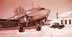
For the present, let’s continue with what I recall from the 1959-1960 era. I was based at MDW and so did not get beyond an area bounded by MDW, MSN, MSP, DLH, MQT, PLN and DTW. However, for a DC-3, that is a lot of area to be covered. At this time we had the largest fleet of DC-3’s in the U.S. at 32 and every one of them was completely standardized throughout. We also had 5 Convair 340/440’s that we had purchased from Continental Airlines in the early spring of ’59. NCA operated under a certificate that said it could fly day/night and VFR/IFR. Because the company maintained a near 24/7 dispatch department at MSP, NCA flights were able to operate without an actual ATC clearance when VFR conditions existed. When weather permitted we did operate VFR and flew at altitudes of even + 500’ west bound and odd + 500’ east bound. The fact that our dispatch knew where all of the VFR flights were at any given time was all that the FAA required at that time. We were required to give a position report to our dispatcher via HF radio or through the nearest NCA ground station once every hour. Now, since our average stage length was in the area of about :30, we were always in contact with one of our stations and that station in turn, would provide dispatch with our location, i.e.…..”flight 451 on the ground at AUW (Wausau) at 1623Z”. The exception to that was our CHI-DLH non-stop that took about 2:40 in the DC-3 and 2:00 on the CV-340/440. In that case, we did give a position report to dispatch on HF whether IFR or VFR. When on an ATC IFR clearance, we operated as we do today……odd altitudes on easterly headings and even altitudes when west bound. I am leaving out any reference to flights at or above 18,000’ because we were not in that league at that time.
So on VFR day or night, if we were headed out of MDW and did not require an IFR clearance, we would call ground control with….….”MDW ground, NCA 17 taxi, VFR north bound”. After we lifted off, the tower would issue us very simple instructions to turn to whatever heading was required. Say for example, we departed on runway 13L and flight 17 was a MKE shuttle; we were simply told to turn left and cleared out of the control area to the north. We would have to be very careful so as not to interfere with inbounds from the east that were on a long base leg for landing on 13 at MDW. We also had to observe that we remained clear of the ORD control area too, as well as Navy Glenview. On that particular flight, we would head N-NE over to and join the shore line in the Evanston area, well north of the CHI Loop. Soon after departing the MDW area, if I was flying, the captain would occasionally reach up and turn off all the navigation radios (both VOR’s and ADF’s) and then he would say…..”take me to MKE” or whatever our next stop was to be. In the early going I was expected to have my sectional chart handy and he would quiz me as to what the names of the various towns were that we were passing. As time went on, I was expected to know the route and town/city names from memory. Remember, our altitude on most flights was in the area of 3,500’ to 5,500’…..so in VFR conditions the view was spectacularly clear…..for the most part. On hazy days you could easily get disorientated, so paying attention to the ground, in addition to the “see and be seen” VFR vigilance, was a full time job to say the least. However, it must be pointed out that there was not nearly as much aircraft traffic in those days as there is today. Please keep that in mind as I take you through this story of flying our ‘59/’60 system. On this particular flight to MKE as we approached the Oak Creek Power plant or off shore at Racine, we would call MKE approach and they would clear us into the control area and provide the wind direction, altimeter setting and active runway info and then advise us to call the tower after passing Oak Creek. At that point they would also advise us of any known traffic in our area…..but understand, we were not in radar contact or control.
At NCA, the legs of the trip were pretty much split 50/50, with the captain, in most cases, starting out from MDW and then I would fly every other leg regardless of the weather or surface wind conditions. Now that was the case with most of the captains. Occasionally, there would be that individual who, for whatever reason, would not share the legs 50/50 and that was his call as the captain. We also had "left seat authority” after completion of the first year. But again, that too was “subject to the captain’s discretion” and is covered in another one of my stories from this time period.
Let us look at flying in that “un-controlled” airspace that I mentioned earlier. For this part of our story, our flight will leave GRB headed for Rhinelander. This is the evening flight 579 that originated at MDW and made stops at MKE, MTW and arriving at GRB along about 2000. It is winter time and the skies are overcast at 1000’ with scattered snow showers over the whole area. RHI is reporting 700-2 with light snow. It is 1959/1960 and the air space to the north of GRB is un-controlled. GRB ground control issues 579 a clearance to depart the GRB control area north of GRB at 4,000’. Our departure is normal and we are soon in the clouds and we maintain 4,000” until our “timing” tells us we are well out of the GRB airspace. We bid the GRB tower “good night” and then climb to 6,000' in the hopes of topping the clouds and getting free of the icing that is taking place. We have the aircraft heater on. It is a gas fired Janitrol heater that uses fuel from the aircraft engine fuel system at the rate of about 2.5 gal per hour. So while winter weather is swirling all around us, we are reasonably warm in the DC-3 cockpit…..having hung a seat blanket from the rear cabin across the bulkhead opening that is immediately behind the two pilot seats. We would leave the top 3’ open so that the stewardess could pass cups of coffee over the top without taking in down. As we continue our climb, we are in luck; we break out “on top” at a bit over 5,000’ and continue the climb to 6,000’. Nearing RHI we contact the station on VHF and give them our fuel on board and ETA for the station. The station comes back with their current weather, which had not changed….still 700 variable OVC 2 miles vis in light snow and wind NW at 5-10 and the current altimeter setting. They would also provide us with a breaking action report…..usually taken with an automobile . “Braking action fair by car” would be the usual report. All of our station personnel were trained and rated as being able to take weather observations that were relayed every hour to MSP dispatch and put out on the hourly teletype weather sequence. The station personnel would use a gas filled balloon to establish the ceiling height. They had various markers, such as fixed, prominent objects around the field to arrive at the visibility value. Next, we would call dispatch in MSP on HF and give them our ETA for the ADF station at RHI and request an approach clearance. NCA dispatch issues a clearance for approach at RHI and advises that they have no known traffic in the area at that time. During this time period the company maintained one of the largest systems of ADF radio stations in the country. They were certified for our use in making ADF approaches to the many airports that we served that were not serviced by the more modern VOR stations found at larger cities and airports in ever increasing numbers across the country. These navigational radio stations formed the NCA Routes that crisscrossed the uncontrolled airspace of our route system and these routes were depicted on our Jepp Airway Charts by thin brown lines that ran between the stations. The ADF approach fell into the category of a “non-precision” approach and was designed to place the aircraft in a position about one mile from the airport and aligned with the runway on a heading that would require no greater heading change than 30 degrees to become properly aligned with the runway of intended landing. A greater change in heading than 30 degrees would then become a circling approach and usually carried with it minimums that were 200’ to 300’ higher than straight-in minimums. Most of the straight-in approach minimums were 400-1 for ADF and VOR approaches unless there was a terrain or other obstruction problem in the area, such as a hill or building structure that stuck up within a few miles of the airport. The minimums would then be 500' or 600'-1 mile. We had approach plates for every airport on the system as provided by the E. B. Jeppesen Company….commonly referred to as “Jepp Charts”. We would choose whichever approach we needed and when cleared for the approach we began our letdown so as to arrive over the station at the prescribed initial crossing altitude while completing the In-Range Checklist. Let’s say for our RHI approach that we would descend to 3,000’ for the initial station crossing altitude for the ADF approach to runway 33, which was 4,500’ long and 100’ wide. When we crossed the station, the needle on the ADF compass would swing from the nose to the tail. On crossing the station, the pilot flying would decrease power and turn the plane so as to place it on a reverse course, away from the station on a heading to pick up the outbound course of the ADF approach. Knowledge of the winds aloft was important as the pilot flying would “hit” the stop watch clock on the instrument panel, noting the time, reduce power and call for the gear down and a quarter flaps and the Landing Checklist. The pilot not flying would advise the station that 579 was over the station starting approach to runway 33 and would then complete the checklist and so state, “Landing Checklist complete, standing by for final flaps”. Both pilots would also be monitoring the amount of ice building on the wings and use the de-icing boots as a means to remove the ice and also give the props a “shot” of alcohol to help stave off icing on the prop surfaces. At times, the cockpit would take on the smell of a brewery as the alcohol fumes from either the props or the windshield alcohol applications drifted in. Meanwhile, the pilot flying would maneuver the plane onto the proper course for the intended landing by proceeding outbound on the prescribed heading for a certain period of time, in this case for 3 minutes after passing the station outbound and all the while watching the relationship of the ADF needle and the compass heading. The approach procedure had to be completed within 10 miles of the station as that was the safe area for the various altitudes of the approach. A procedure turn would be needed to turn the plane back to the inbound course and more altitude would be lost, down to 2,600 in this procedure turn. Once aligned on the inbound course, the altitude would be further decreased to 2,100’ which was 400’ above the field elevation of 1,624’. The pilot not flying then radios the station that 579 is a couple miles southeast while the station agent is on a hand phone at the ramp and gives a final traffic check back to the crew of 579. The pilot not flying is watching for the first signs of the runway lights and/or the airport beacon. This was long before the advent of REIL or VASI……white runway lights and green threshold lights with blue taxiway lights were all we had. And sometimes the snow was so deep that the runway lights were hidden from view…..that was when they began plowing the runways to a point outside of the runway lights…..and that really helped. If the windshield had iced up badly and the heat and alcohol were not enough to clear it away sufficiently, we would then use the putty knife that we always carried and, by opening the side window, be able to reach around and scrape the ice from the outside of the windshield surface. This was really a great experience with the outside temps in the 10 to 15 degree range. The runway lights came into view and final flaps were set and we landed…….called dispatch in MSP with our arrival report and taxied into the gate area…..another “on time” arrival for NCA. Flight 579 would continue on after a very short five or six minute stop at RHI after receiving a clearance from MSP Dispatch for the next leg to IWD. After IWD would be ASH and finally the termination at DLH around 2300 local time. While 579 was making it’s way across un-controlled airspace in the western UP area, other NCA flights were also traversing uncontrolled airspace in the central and eastern UP heading for over night destinations such as CMX, MQT and INR, as well as out in the Dakotas and northern Minnesota. That night, there were probably close to a dozen NCA flights operating in those vast airspaces of our northern route system and one day, in the not too distant future, it would all be under positive radar coverage. But for a few more years, we would ply our skills at an operation that boasted a flight completion factor well into the high 90% numbers, year after year, with a safety record that led the industry. NCA was one of, if not the best, local service carriers in the business.
copyright 2007 - Richard A. Brown
City codes:
MTW = Manitowoc
GRB = Green Bay
RHI = Rhinelander
IWD = Ironwood
ASH = Ashland
DLH = Duluth
CMX = Houghton
MQT = Marquette
INR = Sault Ste Marie
PLN = Pelliston
DTW = Detroit
MDW = Chicago - Midway (also referred to as CHI)
MKE = Milwaukee
MSN = Madison
MSP = Minneapolis / St. Paul
ORD = Chicago - O'Hare
VFR = visual flight rules
IFR = instrument flight rules
ATC = air traffic control
HF = high frequency communication radio
Z = zulu time also known as Greenwich Mean Time
CHI = generic for Chicago
VOR = very high frequency omni range -
ground based navigation radio aid
ADF = automatic direction finder - used to navigate off of
low / medium frequency ground stations
OVC = overcast
REIL = runway end identification lights - two strobe lights
VASI = visual approach slope indicator - used to visually
fly an exact angled descent to the runway
